"Rolly" now super typhoon
Climate Change/Environment • 08:00 AM Sun Nov 1, 2020
1
By:
PanahonTV
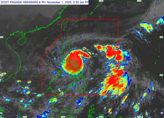
BANTAY BAGYO | #RollyPH intensifies into a Super Typhoon and makes landfall over Bato, Catanduanes.
At 4:50 AM, the center of the eye of Super Typhoon #RollyPH was located in the vicinity of Bato, Catanduanes. It is moving west-southwestward at 25 kph with maximum sustained winds of 225 kph near the center and gustiness of up to 280 kph.
• Within the next 12 hours, catastrophic violent winds and intense to torrential rainfall associated with the region of the eyewall and inner rainbands of the typhoon will be experienced over Catanduanes, Camarines Norte, Camarines Sur, Albay, the northern portion of Sorsogon and the central and southern portions of Quezon. This a particularly dangerous situation for these areas.
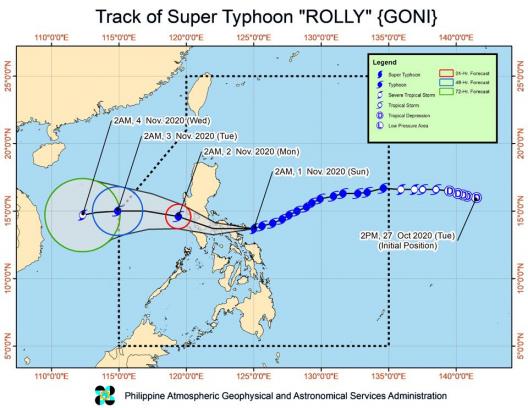
• The center of the eye of Typhoon "ROLLY" made landfall in the vicinity of Bato, Catanduanes at 4:50 AM this morning. After traversing the southern portion of Catanduanes, the center of the typhoon will cross Lagonoy Gulf and make landfall over the southern portion of Camarines Sur or the northern portion of Albay this morning.
• Afterwards, the center will cross the Camarines Provinces before heading towards CALABARZON this afternoon. #RollyPH is forecast to exit the mainland Luzon landmass and emerge over the Philippine Sea tomorrow early morning. During its traverse of Southern Luzon, #RollyPH is forecast to weaken but will emerge as a typhoon over the West Philippine Sea.
• Rainfall: Today, the passage of Typhoon #RollyPH will bring heavy to intense with at times torrential rains over Bicol Region, CALABARZON, Metro Manila, Marinduque, Romblon, Mindoro Provinces, Bataan, Bulacan, Aurora, Northern Samar, Samar, Eastern Samar, Biliran, and the eastern portions of mainland Cagayan and Isabela. Moderate to heavy rains with at times intense rains will be experienced over Cordillera Administrative Region, Leyte, and the rest of mainland Cagayan Valley and Central Luzon. Light to moderate with at times heavy rains will be experienced over Caraga, Northern Mindanao, Zamboanga Peninsula, and the rest of Luzon and Visayas.
•Flooding (including flash floods), rain-induced landslides, and sediment-laden streamflows (i.e. lahar) may occur during heavy or prolonged rainfall especially in areas that are highly or very highly susceptible to these hazards.