Mario slightly weakens as it traverses Babuyan channel
• 04:10 AM Sat Sep 20, 2014
838
By:
Edwin O. Fernandez/PNA
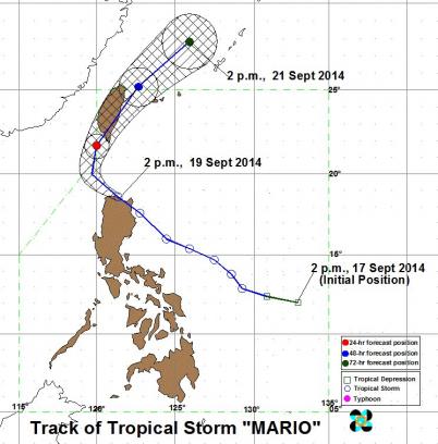
MANILA, Sept. 19 (PNA) -- Tropical storm Mario slightly weakened and slowed down while traversing Babuyan channel Friday afternoon, the Philippine Atmospheric, Geophysical and Astronomical Services Administration (PAGASA) said.In an interview, Christian Ison, PAGASA weather observer, said that as of 6 p.m. the center of tropical storm Mario was estimated based on radar and other available data at 70 km north northeast of Laoag City (18.8°N, 120.8°E).Tropical storm Mario has slightly weakened its maximum sustained winds strength from 85 kph on Friday morning to 75 kph in the afternoon while its gustiness also decreased from 100 kph to 90 kph.According to Ison, the tropical storm weakened due to interaction of landmass.He also said the tropical storm continues to move west northwest but its speed decelerated from 22 kph to 19 kph.Maintaining its speed and movement, it expected to make a landfall in Batanes within the day.He said while the tropical storm continues to move to extreme Northern Luzon, expect gradual weather improvement as the southwest monsoon is also expected weaken.Mario is forecast to be at 216 northwest of Itbayat, Batanes by Saturday afternoon and at 499 km north northeast of Itbayat, Batanes or outside the Philippine Area of Responsibility (PAR) by Sunday afternoon.Ison also said that Cagayan including Calayan and Babuyan Group of Islands, Batanes Group of Islands, Apayao and Ilocos Norte are still under public storm warning signal No. 2 , which indicates winds of 61 to 100 kilometers per hour coming in at least 24 hours.Meanwhile, storm warning signal No. 1 (winds of 30-60 kph expected in at least 36 hours) is hoisted over Isabela, Kalinga, Mt. Province, Abra and Ilocos Sur. These areas are expected to have gusty winds with moderate to occasionally heavy rains, PAGASA said.It warned residents under public storm warning signals against possible flash floods and landslides due to heavy rains.The estimated rainfall amount is from 7 to 20 millimeters per hour (heavy to intense) within the 350-km diameter of the storm.Meanwhile, public storm warning signals elsewhere are now lowered.Meanwhile, Ison said that moderate to heavy rains and thunderstorms in Metro Manila and the rest of Luzon are still expected which may trigger flashfloods and landslides due to the combined effect of the southwest monsoon and TS Mario. It added that fisherfolks and those with small seacrafts are advised not to venture out over the western seaboard of Northern Luzon, seaboards of southern and Central Luzon and Visayas. (PNA)FPV/CLTC